Antibes Ramparts Walking Map: 2025 Architectural Guide
Use our Antibes ramparts walking map for a 2025 self-guided tour. Discover historic walls and coastal views in France. Start your architectural journey today!
On this page
Antibes is a stunning city on the French Riviera. Its ancient sea walls are world-famous for their beauty. Our Antibes ramparts walking map offers a clear path. Follow this guide to see the best coastal sites.
Many travelers love the mix of sea and stone. The ramparts have protected this city for centuries. You can see the snowy Alps across the water. This walk is perfect for any history enthusiast in 2025.
The journey along the coast is truly peaceful. You will find hidden spots along the way. Each corner reveals a new piece of French heritage. Let us explore these famous fortifications together.
The Rich History of the Antibes Ramparts
The ramparts began as simple Greek fortifications. Later, the Romans expanded the defensive walls for trade. In the 16th century, military architects rebuilt them. They wanted to protect France from sea attacks.
King Henry IV started the modern wall design. He hired engineers to create strong stone barriers. These walls survived many wars and sieges. Today, they stand as a symbol of strength.
You will notice the thick limestone blocks used. These stones came from local French quarries. They have weathered centuries of salt and wind. Their golden hue looks amazing at sunset.
Walking these walls feels like entering another time. The path follows the natural curve of the coast. Military precision is visible in every corner. This is why the area remains popular.
You can see the Chateau Grimaldi architecture during your stroll. It stands tall above the thick sea walls. The castle and ramparts work together for defense. This historical site is essential for visitors.
Starting Your Walk at Port Vauban
Begin your tour at the famous Port Vauban. This is Europe's largest marina for private boats. You will see luxury yachts and old fishing vessels. It is the perfect place to start.
Look for the massive stone archways near the water. These gates once controlled entry to the city. The masonry shows high levels of skilled craftsmanship. Take a moment to admire the scale.
The walking path leads directly onto the sea wall. The ground is made of old, worn stones. Wear comfortable walking shoes for this 2025 trip. The path is flat but can be uneven.
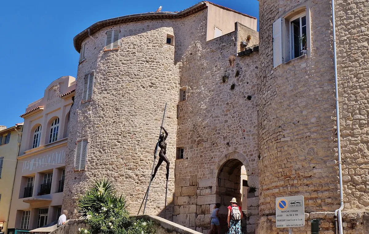
Check your Antibes ramparts walking map at this point. Ensure you are heading toward the Nomade sculpture. This giant statue sits on a high bastion. It looks out over the Mediterranean Sea.
Exploring the Promenade Amiral de Grasse
The Promenade Amiral de Grasse is the main walkway. It stretches along the top of the ramparts. The sea views here are absolutely breathtaking. You will see the blue water for miles.
Many artists have painted this specific coastal view. The light here is bright and very clear. You can find plaques explaining the local history. Stop to read about the different bastions.
The walls are several meters thick in this section. They were designed to withstand heavy cannon fire. You can see the old arrow slits nearby. These details make the walk very interesting.
This part of the Antibes Old Town architectural walking tour is iconic. It connects the harbor to the southern beaches. Most people take about one hour here. Enjoy the breeze while you walk south.
Architectural Highlights of Bastion Saint-Andre
Bastion Saint-Andre is a major highlight on your map. It now houses an interesting archaeology museum. The building itself is a defensive masterpiece. It was built to protect the southern flank.
Notice the low, sturdy profile of the bastion. This design helped it survive many historic battles. The windows are small and set deep in stone. This keeps the interior cool during summer.
You will see ancient pottery inside the museum. These items were found in the sea nearby. They prove that Antibes was a busy port. History is visible in every single stone.
- Museum Entry: Around 3 Euros per person.
- Opening Hours: 10:00 AM to 6:00 PM daily.
- Key Feature: Panoramic roof with city views.
The roof offers a 360-degree view of Antibes. You can see the mountains and the sea. It is the best photo spot in town. Do not miss this during your walk.
The Transition to Plage de la Gravette
The ramparts also lead to Plage de la Gravette. This is a small, sandy public beach. It is tucked behind the stone sea walls. The water here is very calm and blue.
The beach provides a break from the stone paths. Many locals come here to swim in 2025. It is a great place for a rest. You can see the wall from below.
Looking up at the ramparts is very impressive. You realize how high the fortifications truly are. The stone looks like a natural cliff side. It protects the beach from heavy winds.
Access the beach through the old stone tunnel. This tunnel goes right through the main wall. It is a cool and shady passage. Follow your map to find the entrance.
Planning Your 2025 Visit to Antibes
Antibes is best visited during the spring months. The flowers are in bloom along the walls. Temperatures are mild and perfect for long walks. Summer can be quite hot for walking.
Start your walk early in the morning hours. This helps you avoid the large tour groups. The light is also better for your photos. You will have the path mostly alone.
There are many cafes near the ramparts. Stop for a coffee in the Old Town. This supports the local shops and businesses. You will find great food near the market.
Study the architecture in Antibes before you arrive. Knowing the history makes the walk more fun. You will recognize the different building styles. It makes the trip very rewarding.
Frequently Asked Questions
How long does it take to walk the Antibes ramparts?
The walk usually takes about 60 to 90 minutes. This depends on how often you stop. Most visitors spend extra time taking photos. It is a very easy and flat walk.
Is the Antibes ramparts walking map free to use?
Yes, you can use our guide for free. Many local tourist offices also provide maps. The route is very easy to follow. You just stay along the sea wall.
Are the ramparts accessible for wheelchairs?
Most of the Promenade Amiral de Grasse is flat. Some sections have ramps for easier access. However, some old stairs can be difficult. It is best to check recent 2025 maps.
What is the best time of day for the walk?
Sunset is the most popular time for visitors. The golden hour makes the stones glow. Early morning is also very peaceful and quiet. Avoid the heat of the afternoon sun.
Can children walk on the Antibes ramparts safely?
The path is safe for children of all ages. There are sturdy railings along the sea side. Just keep a close watch near the stairs. It is a great family activity.
The Antibes ramparts walking map is your key to history. Walking these ancient walls is a magical experience. You will see the best of the Mediterranean. Plan your trip for 2025 and enjoy the views. Start your journey in the heart of the Old Town today.
Key Takeaways
- Wear comfortable shoes for the stone paths.
- Visit the Bastion Saint-Andre for the best views.
- Walk at sunset to see the stones glow.
- Bring a camera for the stunning Alpine backdrop.
- Combine the walk with a visit to the Picasso Museum.
Related reads: architecturebycity.com, safranier district facades.