Blois Urban Development History: A Complete Guide
Explore the rich Blois urban development history. Learn how this French royal city evolved from medieval roots to a modern 2025 destination with our guide.
On this page
Blois offers a fascinating look into Blois urban development history for every curious traveler today. This stunning city sits gracefully along the banks of the scenic Loire River in central France. In 2025, visitors still feel the deep architectural layers of this historic royal destination. Exploring the streets reveals how different eras merged to create a unique urban landscape.
The current layout reflects centuries of growth driven by political power and changing economic shifts. Most people start their journey at the famous royal castle overlooking the vibrant town center. From there, the city descends toward the water in a series of historic winding steps. You can find various Blois architectural styles throughout the narrow streets and wide squares.
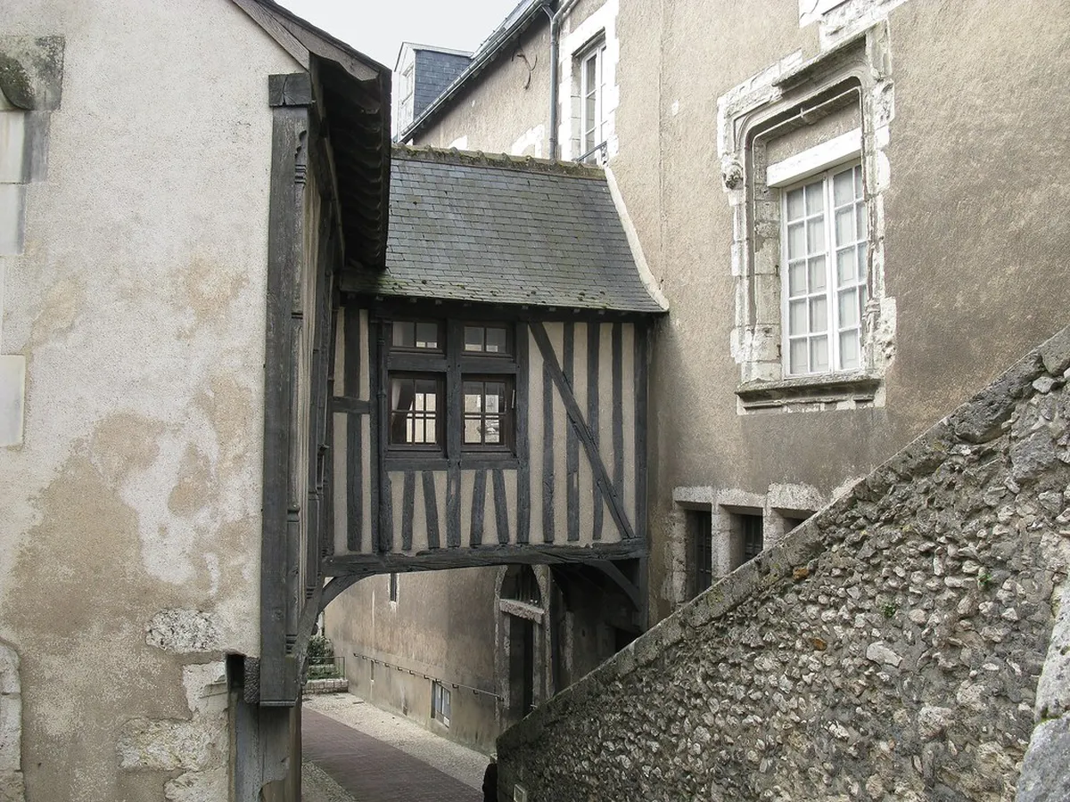
Medieval Foundations and River Growth
The early Blois urban development history began with a small settlement on a limestone promontory. Medieval builders chose this high ground to protect the residents from frequent river floods. They constructed thick defensive walls to secure the growing population against potential invaders and raids. These ancient fortifications defined the circular shape of the oldest parts of the city center.
During the Middle Ages, the city expanded rapidly toward the banks of the Loire River. Merchants built narrow houses close together to maximize the limited space inside the city walls. This era created the dense network of alleys that tourists love to explore in 2025. You can still see several half-timbered buildings that survived the passage of many centuries.
The religious institutions also played a major role in shaping the early urban layout of Blois. Large monasteries and churches acted as secondary hubs for development outside the main castle gates. These sites encouraged people to build homes and workshops in previously empty rural areas nearby. This decentralized growth helped the city expand its reach across the challenging hilly terrain.
Water management was another critical factor in the medieval planning of this busy riverside town. Citizens dug deep wells and built stone fountains to provide clean water for the local neighborhoods. The river served as the main highway for transporting goods like wine, wood, and stone. Strategic docks along the shore became the primary economic engine for the entire Blois region.
- Early Walls: Defined the initial boundaries of the medieval city.
- River Access: Enabled trade and transportation for local merchants.
- Hilltop Forts: Provided essential defense for the royal residents.
Renaissance Expansion and Royal Influence
The Renaissance brought a golden age for Blois and its significant urban development history. Kings of France moved their court to the city and invested heavily in grand projects. This royal presence transformed the town from a simple fortress into a sophisticated center of art. Large mansions for the nobility began to replace smaller, older medieval structures in the center.
Urban planners of the sixteenth century focused on creating better views and more open spaces. They opened new passages to connect the castle with the rest of the growing town. You can study the transformation of Blois castle surroundings to see these royal changes. The addition of formal gardens brought a sense of order to the wild landscape.
New architectural techniques allowed for taller and more decorative buildings during this prosperous time. Stone became the preferred material for wealthy families who wanted to show their high status. Elaborate facades with carved details started appearing on the main streets near the royal residence. These improvements made Blois one of the most beautiful cities in the entire kingdom.
The arrival of the royal court also required better roads for carriages and horses to travel. Workers paved the main thoroughfares with durable stone to handle the increased traffic and weight. This modernization effort improved the connection between the upper castle and the lower river markets. It set the stage for the modern transportation networks that exist in the city today.
Public life shifted toward the new squares where festivals and royal ceremonies took place regularly. These open areas provided a break from the narrow and crowded streets of the old town. They also allowed for better air circulation and light in the densely packed urban core. The Renaissance legacy remains the most visible part of the city for modern visitors.
Industrialization and Modern Infrastructure
The eighteenth and nineteenth centuries introduced modern infrastructure to the Blois urban development history. A major highlight was the construction of a grand stone bridge across the Loire River. This engineering marvel improved trade and linked the city with southern regions of France. You can visit the Jacques Gabriel Bridge to admire its classic design.
Railways arrived in the mid-1800s and changed the city layout once again for everyone. The station was built on the outskirts, which pulled the urban growth toward the west. New residential neighborhoods appeared near the tracks to house the growing workforce for local factories. Industrial zones started to occupy the land along the riverbanks away from the center.
City officials also focused on improving public health by modernizing the old sewer systems. They widened several streets to allow for more sunlight and better ventilation in poor areas. These changes were inspired by the urban reforms taking place in Paris during that era. Blois became a cleaner and more efficient city for its residents and many visitors.
Parks and public gardens became a priority for the urban planners in the late 1800s. They converted former royal lands into green spaces for the enjoyment of the general public. These areas provided a natural escape within the stone-heavy environment of the historical city. Today, these parks remain popular spots for locals to relax during the warm summer months.
The introduction of gas lighting and eventually electricity transformed the nighttime appearance of the city. Streets became safer for travel and social activities after the sun went down in Blois. Commercial districts expanded as shops could stay open later into the evening for their customers. This modernization marked the transition into the urban life we recognize in 2025.
Post-War Reconstruction and Contemporary Growth
The events of World War II left deep scars on the Blois urban development history. Bombings destroyed many buildings near the river and the main bridge in the early 1940s. After the war, architects faced the huge task of rebuilding the heart of the city. They chose to blend traditional styles with modern construction techniques for the new projects.
Planners during the reconstruction aimed to respect the original street patterns while improving overall functionality. They used local stone to ensure the new buildings matched the historic character of the town. This careful approach preserved the visual harmony that makes the city center so attractive today. Many residents consider this period a success in modern urban planning and design.
In the late twentieth century, Blois expanded further with new suburban housing developments. These areas were designed to accommodate the growing population and the rise of car ownership. Modern shopping centers and office parks appeared on the outskirts of the historical urban core. You can see modern and contemporary architecture in Blois in these newer districts.
Today, the focus has shifted toward sustainability and pedestrian-friendly zones in the central city. Officials are working to reduce car traffic in the oldest neighborhoods to protect historic stone. New bike paths connect the suburbs with the riverfront and the famous royal castle area. These projects aim to make the city more livable for the next generation.
Public transit systems have also seen significant investment to connect different parts of the city. Modern buses and shuttle services make it easy for tourists to reach the main sites. The integration of technology helps travelers navigate the city more efficiently in the year 2025. Blois continues to evolve while keeping a firm grip on its historical roots.
The Impact of Topography on City Planning
The unique geography of the region has always influenced Blois urban development history significantly. The city is built on a series of natural terraces that rise from the river. This vertical layout created a natural separation between different social classes in the past centuries. The wealthiest residents often lived on the higher ground near the royal castle walls.
Navigating the steep slopes required the construction of many stone staircases and narrow ramps. These features are a defining characteristic of the topography and terraced streets of Blois. Walking these paths offers spectacular views of the rooftops and the river valley below. Engineers had to be very creative to build stable structures on such uneven ground.
Retaining walls are visible everywhere in the city to prevent erosion of the soft limestone. These walls often serve as the foundations for houses or public gardens in the center. The use of local stone makes these functional elements look like part of the art. Maintaining these ancient structures is a constant challenge for the modern city government today.
The terraced design also influenced how water flows through the city during heavy rain storms. Ancient drainage systems were built to channel water safely down to the Loire River below. Modern planners must still account for these natural paths when designing new building projects. The hills provide both a beautiful aesthetic and a complex engineering puzzle for everyone.
Building in Blois requires a deep understanding of the underground caves and old stone quarries. Many houses sit directly on top of vast tunnels used for storage or wine cellars. This hidden layer of the city adds another dimension to its long urban history. It reminds us that the city exists both above and below the visible surface.
Frequently Asked Questions
How did the Loire River influence Blois urban development history?
The river was the primary source of trade and transportation for the early city. It dictated where the first docks and markets were built along the shore. Flood risks also forced the city to expand upward onto the nearby hills. Today, the river remains a central feature for tourism and local recreation.
What is the most famous historical site in Blois for architecture?
The Royal Chateau de Blois is the most significant site in the city center. it showcases four distinct architectural styles from different centuries in one single location. This building served as the catalyst for most of the urban growth nearby. It remains the top destination for visitors interested in French royal history.
Did World War II change the layout of Blois?
Yes, significant parts of the lower city were destroyed during the war years. The reconstruction process followed the original medieval street plans but used modern building materials. This allowed the city to maintain its historic feel while improving safety and housing. You can still see the difference between the old and rebuilt sections.
Is Blois a walkable city for tourists in 2025?
Blois is very walkable but features many steep hills and stone staircases. Most major historic sites are located within a short distance of the castle. The city has invested in pedestrian zones to make exploring the center much safer. Comfortable shoes are highly recommended for anyone planning to walk the terraced streets.
The Blois urban development history is a testament to the resilience of French architecture. From royal palaces to modern bridges, the city has adapted to every era's unique needs. Visitors in 2025 can experience this journey by walking through the diverse neighborhoods today. Plan your trip soon to see how history and modern life coexist beautifully. Explore the streets and discover the secrets hidden in the stone of this royal city.
Key Takeaways
- The Loire River was the original economic driver for the city.
- Royal influence in the Renaissance created the grand urban layout.
- World War II reconstruction carefully preserved the historic visual harmony.
- Unique topography led to the creation of famous terraced streets.
- Sustainability and pedestrian access are the current focus for 2025.
Related reads: architecturebycity.com, chateau de blois architectural styles.