Roman Durocortorum Urban Planning in Reims
Explore Roman Durocortorum urban planning in Reims. Learn about ancient grid designs and architectural ruins in this 2025 guide. Plan your historic visit today!
On this page
The ancient city of Reims holds a deep history hidden beneath its busy modern streets. Roman Durocortorum urban planning shaped this vital region during the first century. This settlement served as a major capital for the Remi tribe in Roman Gaul. Planners used a strict grid system to organize the growing city very efficiently.
Durocortorum became one of the largest cities in the vast Roman Empire. Its design focused on trade, military movement, and social order within the province. Today, travelers can still see traces of this grand ancient vision in modern France. This guide explores the engineering marvels that defined this historic urban center.
Foundations of Roman Durocortorum Urban Planning
The layout of the city followed a very specific and strict geometric pattern. This design allowed for the easy movement of Roman troops and heavy supplies. Most Roman cities in Gaul used this standard urban model for consistency. Reims became a central hub for trade and local political power.
Engineers carefully measured the land to create a perfect orthogonal grid system. They established clear boundaries for residential zones and large public marketplaces. This organization helped manage the rapidly growing population of the ancient capital. Modern excavations continue to reveal the precision of these early Roman builders.
The grid system also facilitated the construction of advanced drainage and sewage systems. Water management was a primary concern for the architects of ancient Durocortorum. They built stone channels beneath the streets to keep the urban area clean. This early infrastructure supported a high standard of living for the citizens.
Property lines were clearly marked to prevent legal disputes among the wealthy residents. Each city block, or insula, housed various shops and private domestic dwellings. These blocks were uniform in size to maintain the visual harmony of the city. Such planning reflects the sophisticated governance of the Roman administration at that time.
Urban planners prioritized safety by creating wide streets for better visibility and access. These avenues allowed horse-drawn carriages to pass each other without causing traffic jams. Pedestrians enjoyed dedicated walkways that were separated from the main animal traffic. This careful consideration of movement made Durocortorum a model of Roman efficiency.
The Role of the Cardo and Decumanus
Every Roman city centered around two main intersecting streets for better navigation. The Cardo Maximus ran north to south through the heart of Durocortorum. The Decumanus Maximus intersected it from east to west at the central forum. These two roads formed the primary skeleton of the entire urban landscape.
The intersection of these roads created a natural gathering place for the local population. Vendors set up stalls near this junction to attract the most passing foot traffic. You can still follow these ancient paths while exploring the modern city of Reims. The cryptoporticus Gallo-Roman architecture remains a stunning example of this central design.
The orientation of these streets often aligned with the cardinal points of the compass. This alignment helped residents navigate the city even during the darkest winter months. Planners also considered the direction of the sun to provide natural light for buildings. Such attention to detail shows the advanced scientific knowledge of Roman architects.
Secondary streets branched off from these main arteries to reach the quieter residential areas. These smaller roads were often paved with local limestone for durability and easy repair. Maintenance crews worked regularly to keep these vital paths clear of debris and waste. This systematic approach to roadwork ensured the city remained functional for centuries.
Grand Gates and Defensive Structures
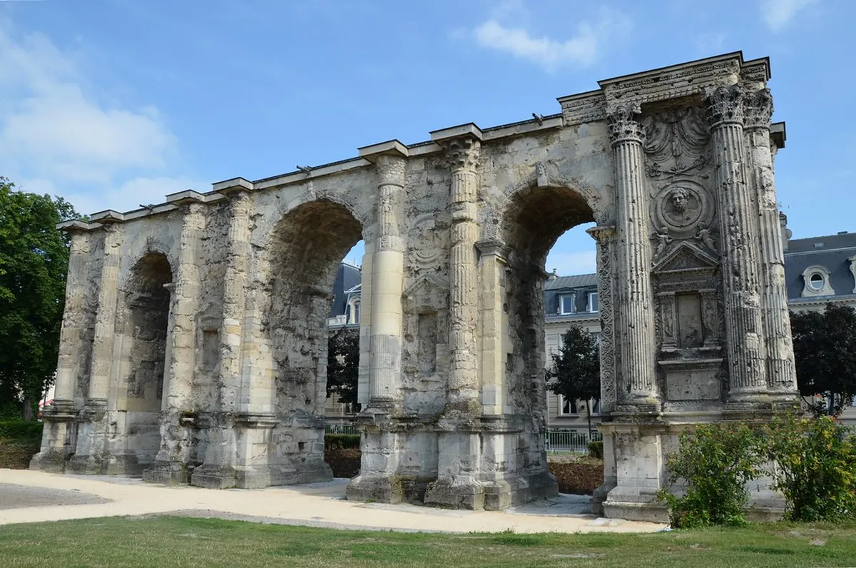
Defensive walls were essential for protecting the wealth and people of Durocortorum. These fortifications featured grand gates that served as impressive entrances to the city. The most famous remaining structure is the massive and ornate Porte de Mars. Learn about the Porte de Mars structural history to understand its military and symbolic importance.
The gate stands as the widest Roman arch in the entire world today. It features three distinct arches and intricate carvings depicting ancient Roman myths and legends. Visitors in 2025 can admire the detailed stonework that has survived for centuries. This monument served as a powerful symbol of Roman authority in northern Gaul.
Smaller watchtowers were placed at regular intervals along the thick perimeter of the walls. These towers provided a clear view of the surrounding countryside for early threat detection. Soldiers patrolled the upper ramparts to ensure the safety of the busy urban population. The walls defined the physical limits of the city for many generations.
During the late Roman period, these walls were strengthened to resist frequent barbarian invasions. Architects recycled materials from older buildings to reinforce the heavy defensive stone layers. This transition highlights the changing priorities of urban planners during times of political unrest. Today, fragments of these walls are visible in various parks around Reims.
Public Infrastructure and Water Engineering
Roman engineers excelled at bringing fresh water into large and crowded urban centers. They constructed long aqueducts to transport water from distant springs to the city. This water supplied public fountains, large bath complexes, and wealthy private homes. Access to clean water was a basic right for the people of Durocortorum.
The public baths served as a social hub for relaxation and political discussion. Residents would visit these facilities daily to bathe and meet with their friends. These buildings featured advanced heating systems called hypocausts located beneath the tile floors. This luxury was a hallmark of the Roman lifestyle in the Gallic provinces.
Waste management was equally important for maintaining public health in a dense city. A network of sewers carried waste away from the residential areas to nearby rivers. These tunnels were large enough for workers to enter and perform necessary cleaning tasks. This engineering feat prevented the spread of many common urban diseases.
The forum served as the primary administrative and religious center of the community. Large temples and law courts surrounded this open paved space for public use. Citizens gathered here to vote, witness trials, and participate in religious festivals. The forum was the physical representation of Roman civic pride and order.
Visiting Roman Ruins in Reims Today
Travelers visiting Reims in 2025 will find several well-preserved ancient Roman sites. The Musee Saint-Remi houses many artifacts discovered during local urban construction projects. Entry fees for the museum are usually around five euros for adult visitors. You should spend at least two hours exploring the extensive Gallo-Roman collections.
Walking through the city center allows you to see the Roman ruins in Reims for free. The Porte de Mars is located in a beautiful public park near the train station. It is a perfect spot for photography and relaxing in a historic setting. Many information plaques explain the significance of the site in multiple languages.
The Cryptoporticus is another must-see site located beneath the Place du Forum. This underground gallery once supported a large market or a sacred temple area. It offers a cool escape from the summer heat while revealing ancient construction. Check the local tourist office for current opening hours before your visit.
Guided tours are available for those who want a deeper academic summary of the history. These tours often explain the transition from Roman Durocortorum to the medieval city. Understanding the urban planning helps you appreciate the layout of modern-day Reims. Many streets still follow the exact paths laid out by Romans long ago.
Frequently Asked Questions
What was the population of Roman Durocortorum?
Historians estimate the population reached between 30,000 and 50,000 people at its peak. This made it one of the largest cities in Roman Gaul. The dense urban planning supported this large number of residents effectively.
Where can I see Roman ruins in Reims for free?
You can visit the Porte de Mars and the Place du Forum for free. These sites are located in public areas accessible to everyone at any time. They provide a great look at ancient Roman Durocortorum urban planning.
Is the Roman grid still visible in modern Reims?
Yes, many primary streets in the city center still follow the Roman grid. The intersection of Rue de Vesle and Rue de l'Etape marks the ancient center. You can see this logic in any modern city map.
How old is the Porte de Mars in Reims?
The Porte de Mars was built during the second century, making it nearly 1,800 years old. It has undergone several restorations to preserve its beautiful and complex carvings. It remains a highlight of any historical tour in 2025.
Roman Durocortorum urban planning remains a foundational element of the history of Reims. The grid system and monumental gates showcase the brilliance of ancient Roman engineering. Visitors can still walk the same paths that Roman citizens used centuries ago. Plan your trip in 2025 to experience these incredible architectural wonders in person.
Key Takeaways
- Durocortorum was a major capital city with a strict orthogonal grid layout.
- The Porte de Mars is the widest surviving Roman arch in the world.
- Ancient Roman street patterns still influence the modern map of Reims.
- The city featured advanced water systems, including aqueducts and public baths.
- Visitors can see many Roman sites for free in public parks today.
Related reads: architecturebycity.com, architecture in reims, gothic architecture in reims.